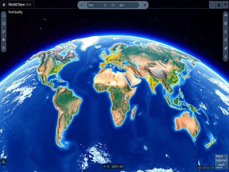
WorldView: A Browser-Based Spy Satellite Simulator
The convergence of artificial intelligence, machine learning, and satellite technologies has opened up new horizons for data analysis and geospatial intelligence. One of the most exciting innovations in this domain is WorldView, a browser-based spy satellite simulator developed by a former Google Maps product manager. This powerful tool not only simulates satellite imagery but also integrates real-time data and AI coding agents, making it a game-changer in various industries.
What is WorldView?
WorldView is an innovative platform designed to provide users with a realistic simulation of satellite imagery. The tool is built on the premise of leveraging existing satellite data and layering it with real-time information to create a comprehensive visualization environment.
- Real-time Data Integration: WorldView allows users to overlay various types of real-time data, such as weather conditions, urban development, and environmental changes, onto satellite imagery.
- AI Coding Agents: The platform incorporates AI agents that can analyze patterns and predict future trends based on historical data.
- User-Friendly Interface: Being browser-based, WorldView is accessible to a wide range of users, from researchers to urban planners and business analysts.
The Vision Behind WorldView
The creator of WorldView recognized a gap in the market for a tool that could not only simulate satellite data but also allow users to interact with that data in meaningful ways. Drawing from his experience at Google Maps, he aimed to democratize access to satellite imagery and make it more actionable for various sectors.
Practical Insights into WorldView’s Capabilities
WorldView is more than just a visualization tool; it offers several practical insights and capabilities that enhance decision-making processes across multiple industries. Here are some key features:
- Urban Planning: City planners can use WorldView to assess land use changes, monitor construction projects, and make data-driven decisions about resource allocation.
- Agriculture Monitoring: Farmers and agricultural analysts can track crop health and monitor soil conditions in near real-time, allowing for timely interventions.
- Disaster Management: Emergency responders can leverage the platform to assess damage from natural disasters, track affected areas, and coordinate relief efforts more effectively.
- Environmental Research: Researchers can analyze changes in ecosystems, track wildlife migration, and study the impact of climate change using the layered satellite data.
Industry Implications
The implications of WorldView extend beyond individual sectors; they touch on broader trends in technology and innovation:
- Increased Accessibility: By making satellite imagery more accessible, WorldView levels the playing field for smaller organizations and startups, allowing them to compete with larger firms.
- Enhanced Decision-Making: The integration of AI coding agents enables organizations to make more informed decisions based on data-driven insights, improving operational efficiency.
- Collaboration Across Sectors: WorldView encourages collaboration between industries—such as urban planning, agriculture, and environmental science—by providing a shared platform for analysis.
Future Possibilities with WorldView
As technology continues to evolve, so too will the capabilities of WorldView. Here are a few future possibilities that could emerge:
- Real-Time AI Learning: Future iterations could include more advanced AI capabilities that learn from user interactions, providing increasingly personalized insights and recommendations.
- Integration with IoT Devices: By combining satellite data with information from IoT devices, users may gain unprecedented insights into urban dynamics and environmental conditions.
- Augmented Reality (AR) Features: The platform could incorporate AR features that allow users to visualize data in a three-dimensional space, enhancing the interactive experience.
- Global Collaboration: As more organizations adopt WorldView, we may see a global network of users who collaborate to share insights and data, fostering innovation on a broader scale.
Conclusion
WorldView represents a remarkable advancement in the field of satellite technology and data visualization. By combining real-time data with AI-driven analysis, it empowers users across various industries to make informed decisions that can lead to significant improvements in efficiency and effectiveness. As we look to the future, the possibilities for enhanced features and greater collaboration could redefine how we understand and interact with our world.

